
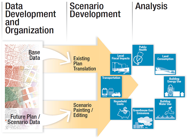
UrbanFootprint is a tool to help the public and public officials determine the best scenarios and outcomes for their communities, using scientific research and data about real places where people live and work. UrbanFootprint lets users look at current land use plans in their communities and visualize the potential for where new people, buildings, and urban amenities might go as population grows in the future.
The software helps users experiment with the amount and location of land use and place types – such as residential, commercial, and open space – to create their own development scenarios. Information on household costs, public health impacts, building energy and water use, greenhouse gas emissions, land consumption, and transportation for scenarios can help identify the best land use option. Users can make planning decisions based upon possible outcomes and identify future patterns of development for their community.
Why is UrbanFootprint Important in Planning?
Planning is inherently about vision. What communities wish to see in their neighborhoods, how they choose to go about their day to day routine, and what it takes to get there, literally and figuratively. Creating consensus around the big picture takes a lot of people, with a lot of ideas, working together.
Current-day land use planning has always relied on process and a variety of tools and maps to show impacts of land use development decisions of future growth. As a dynamic tool, UrbanFootprint provides a way to have an organized, recordable, and consistent method to visualize land use options and estimate future outcomes. UrbanFootprint provides a faster, more efficient way to leverage limited staff resources to identify development scenarios and their impacts, working side by side with stakeholders to quickly create, test, and discuss many alternatives much, much faster than traditional tools, and at lower cost.
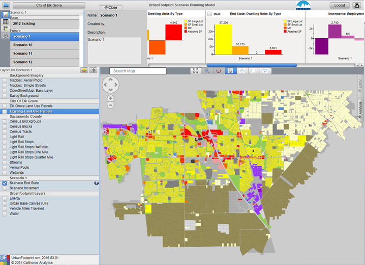
Screen shot of the software in use
Potential Applications
Communication
- Users can communicate impacts of land use plans in understandable maps, charts, graphs and tables.
- Provides an effective tool for decision makers, public agency staff, and the public to identify land use planning options
- Facilitates dialogue between and across state, local, and regional agencies.
- Creates a common platform for stakeholders to depict a wide range of land use and planning concepts and scenarios
Exploration
- Empowers local communities to understand the relationships between what gets built and the health, environment, and economic impacts of development.
- Creates an outlet for local and regional public agencies to coordinate and leverage planning efforts.
- Puts scientific studies to work to estimate the outcomes of land use patterns and transportation networks
- Creates a classroom tool for use in public policy, planning, transportation, economics, sociology, public health and other courses
Policy Development
UrbanFootprint can be used for policy development at the local, regional, and state level:
Local
- General Plan development and updates
- Sustainability planning
Regional
- Sustainable Communities Strategy development and updates
- Determine impacts on a regional scale
- Sustainability planning
- Understand relationships between local plans with regional investments
State
- Understanding local and regional policy impacts, and the statewide implications
- Depicts regional and local policy shifts around development and conservation